Memory “Placed” in Sunset Park, the Ephemeral yet Enduring
Sunset Park in Brooklyn, NY, a vibrant, diverse and inclusive community, provides a sense of home for many who just immigrated to the United States, the Irish, Polish, Finish and Norwegians in the early days and the Chinese and Puerto Ricans in the recent decades. As one facet of the urbanization process, brownstones, limestones and brick, and wood row houses were erected on this piece of long-term farmland at the turn of the 20th century (Jackson and Manbeck, 201). Industrial development around the Bush Terminal, present-day Industry City, paralleled the construction of housing stocks and railroad systems. Besides regular commercial activities, the facility was also commandeered by the federal government during the war periods. This manufacturing complex along the waterfront reached its peak of production before World War II. The Terminal gradually fell into decline as other types of freight shipping and more ports began to emerge. Along with the degeneration of this local anchor, the Great Depression also struck the economy in Sunset Park, and the neighborhood went into an era of disrupted real estate and poverty (Ibid). As another wave of immigrants infused energy, skills, and aspiration to the area, this resilient community held up. With internal support and external aides, Sunset Park embraced a rebirth in the 1960s and continued to grow since then.
|
Unfortunately, this irreplaceable refuge is now endangered by immense development pressure and rampant gentrification in the neighborhood and surrounding areas. New developments such as the conversion of Industry City to the Innovation Lab and the Eighth Avenue mega building project have spurred up rapid gentrification and displaced numerous long-term residents in Sunset Park, who are mostly working-class people of color and immigrants. Investors and development corporations have harnessed their economic capital and political capacity to realize their vision and to maximize their profit. Industry City’s proximity to the waterfront (Figure 2) once nurtured its historic shipping, warehousing, and manufacturing businesses but now this lucrative asset poses a threat to the local working and living population. Erasing the existing manufacturing jobs, this emerging creative hub, however, cannot ensure sustainable and justly compensated employment opportunities suitable for the local residents. Boutique shops and cafes moving into the area foreshadow an influx of bourgeoisie consumers. Private money
|
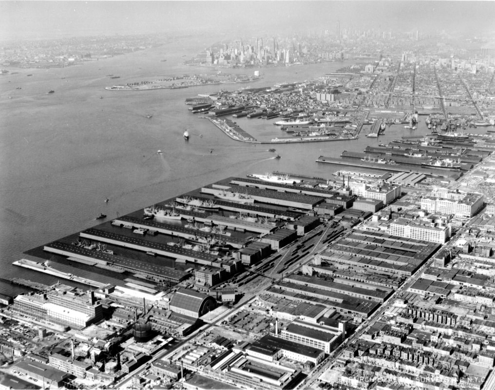
Figure 1 “Aerial view of Bush Terminal, Brooklyn, New York, on New York Harbor.”
|
develops housing complexes targeting the upper-middle class; even the so-called “affordable units” in those buildings are in no way affordable for the local blue-collar residents. On the other hand, long-term residents are forced to leave their old homes and even the neighborhood due to the skyrocketing rent. Even those who remain in the neighborhood can feel displaced emotionally when they witness the close-down of familiar shops, neighbors moving out and disinvested infrastructures.
Betty Yu, a New York City-based multimedia artist, grew up in Sunset Park and still frequents the area to visit her parents and organize events. In her current project, “(Dis)Placed in Sunset Park,” Betty collects stories from Latinx and Chinese residents in the neighborhood. She frames her project around the concept of counter-mapping. Maps possess a sense of objectivity and validity that other art mediums might be lacking (Yu). On the contrary, maps imply the value and vision of their makers and are never unbiased. For example, the problematic redlining maps categorize certain neighborhoods as hazardous simply based on racial composition and try to legitimize inequitable treatment to these areas. Capitalizing on maps’ authoritative attribute, “counter-mapping is a community-led mapmaking process where people appropriate the techniques of formal mapping used by government and industry to lift up underrepresented people, uncover untold histories, and bring to focus places that are not recognized by dominant narratives (Ibid).”
Betty presents the collected narratives in video and written forms in her exhibition at the Open Source Gallery, online and through an Augmented Reality (AR) app. Betty also displays archival photos and maps of the neighborhood in the gallery space. A cabinet at the corner (Figure 2) holds Betty’s research on Sunset Park’s history and materials on zoning, gentrification, displacement and etc. Besides the visual and audio elements in the show, sifting through these files and leaving comments in the notebook (Figure 3) arouse the visitors all five senses and create a tactile and moving experience.
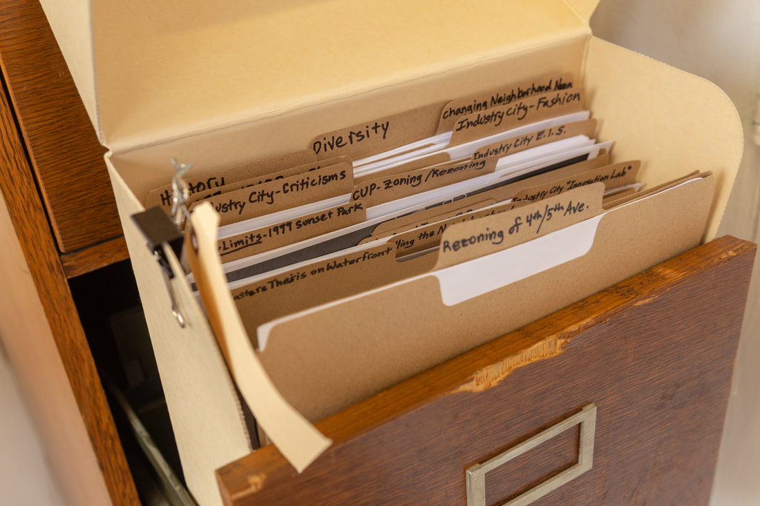
Figure 2 Research Cabinets
|
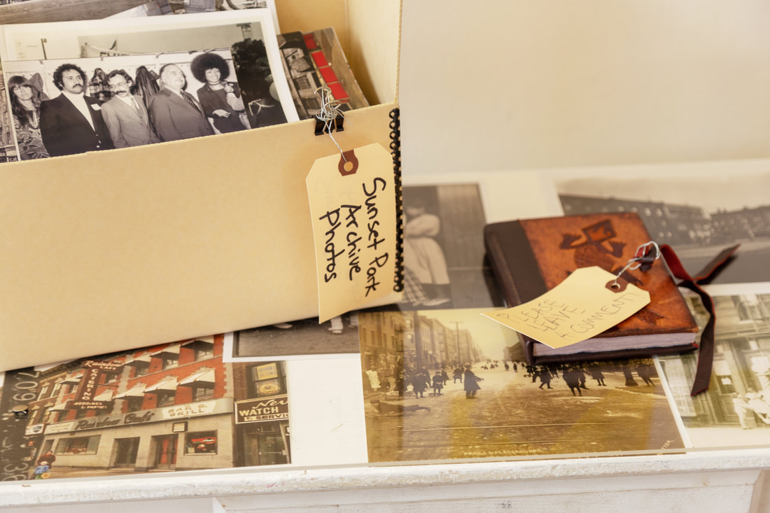
Figure 3 Objects
|
The “(Dis)Placed in Sunset Park Placekeeping Walk” is another activity that engages with all the participant’s five senses. The refreshing breeze, smell of food at local shops and chortle of kids hanging out in the park painted a lively community enjoying a relaxing Saturday afternoon. Instead of a guided tour, this placekeeping walk accentuated a sensual and engaging experience. As participants meandered through the park with an observation protocol, they directed more attention to the mundane, the seemingly insignificant fragments of everyday life which as a whole defined the local social life. General social history is composed of numerous individuals’ narratives. When Betty and people on the tour shared their ties to the neighborhoods, struggles and achievements (Figure 4), their personal stories pieced together the larger picture of Sunset Park, which reflected the major movements and challenges faced by the neighborhood while retained an intimacy and urgency that could reach people dear to the hearts.
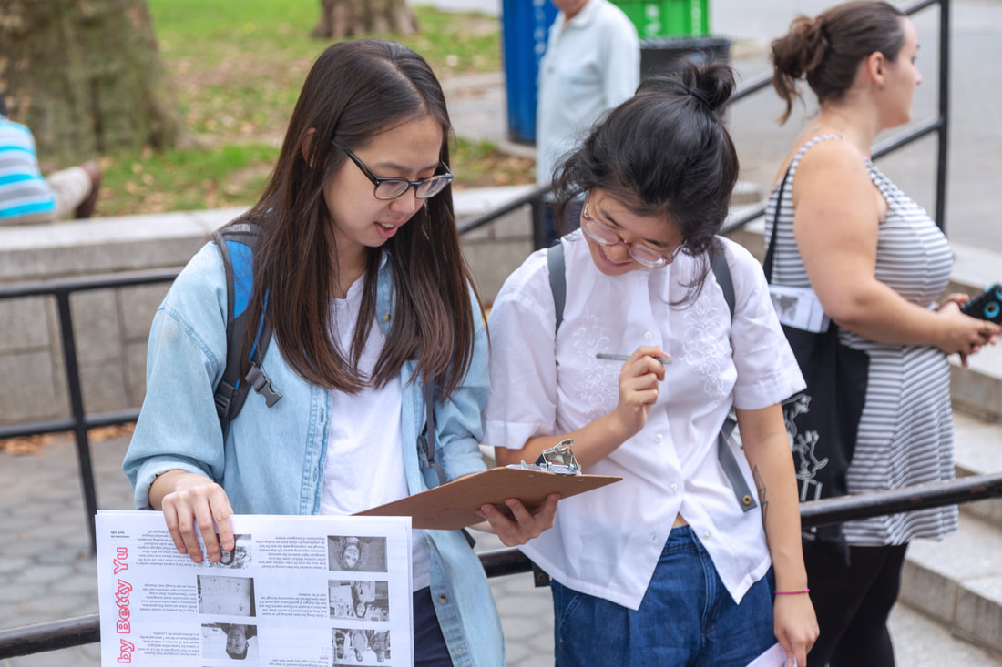
Figure 4 Walking Tour Activity
|
Betty also utilizes AR to create a virtual tour so people can explore the narratives without geographic limitations (Figure 5). Those who are able to visit the featured locations in person can access stories by pointing their phones to the buildings through the app (Figure 6). Having people who are displaced to tell their stories right in front of their childhood homes, past workplaces and familiar storefronts allows them to temporarily reclaim ownership to their old-time spaces. Naming a street or placing a plaque on a cornerstone demands financial input and the ability to navigate the systems; most people in Sunset Park have access to neither. This AR project thus imprints another layer of history, that is not celebrated in the mainstream version, into the physical fabric in a more fluid form. Similar to
|
Betty’s approach, artists across the globe have used the projection of images and videos and other mediums to shed light on alternative stories without leaving permanent markers. However, although these videos require activation through the app, the narratives are permanently housed on the digital platform. Moreover, they cannot be easily erased from people’s mind and body: memory is ephemeral yet enduring.
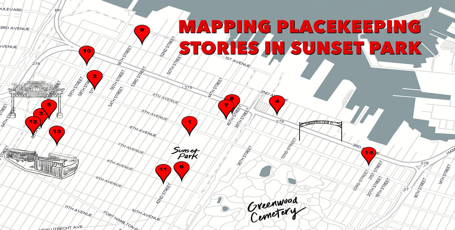
Figure 5 "Map of Virtual Tour"
Anthropologist Edmund Leach says, “it is not just that ‘places’ serve to remind us of the stories that are associated with them; in certain respects, the places only exist… because they have stories associated with them (Potteiger and Purinton, 23).” Through “(Dis)Placed in Sunset Park,” Betty revives and sustains the Sunset Park fresh in her and her fellow resident’s memory. The abandoned Chinese laundromat, the closed-down factory and the “Work in Progress” sign outside a covered vacant lot each tell a unique story. “But when once they have acquired this story-based existence, the landscape itself acquired the power of ‘telling the story,’” Leach goes on (Ibid). Residents in Sunset Park still face a long-haul battle. Nevertheless, their expedition will not cease at the step of raising awareness, what art is typically confined with. The power of the multilayered precious memory cultivated by, rooted in and giving power to the neighborhood safeguards Sunset Park and its people.
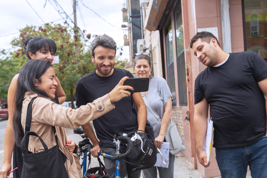
Figure 6 Experimenting with AR App
Works Cited
Jackson, Kenneth T. and John B. Manbeck, eds. The Neighborhoods of Brooklyn, 2004. New Haven, Connecticut: Citizens for NYC and Yale University Press.
Potteiger, Matthew, and Jamie Purinton. Landscape Narratives: Design Practices for Telling Stories, 1998. New York: J. Wiley.
Yu, Betty. “(Dis)Placed in Sunset Park: an interactive multimedia project by Betty Yu.” Betty Yu. http://www.bettyyu.net/displacedinsunsetpark/.
Image References
Figure 1. “Aerial view of Bush Terminal, Brooklyn, New York, on New York Harbor.” Looking north. Photo of Wikipedia. https://en.wikipedia.org/wiki/Industry_City#/media/File:Bush_Terminal_-_North_aerial_-_1958.jpg.
Figure 2. Photo by Di Cui.
Figure 3. Photo by Di Cui.
Figure 4. Photo by Di Cui.
Figure 5. “Map of Virtual Tour.” http://www.bettyyu.net/virtualartour.
Figure 6. Photo by Di Cui.
